Parking guidance systems (PGS) reduce search time for available spaces, improve facility utilization, and reduce vehicle circulation that contributes to emissions and customer frustration. The technology has evolved from simple entry/exit counters to space-level sensor networks with real-time app integration. Understanding the available technologies, their relative costs and accuracy, and how they integrate with parking operations is essential for operators evaluating guidance investments.
Why Parking Guidance Matters
The primary operational case for parking guidance is reducing vehicle search time — the proportion of a parker’s facility visit spent circulating to find an available space. In facilities without guidance, circulating vehicles can represent 15 to 30 percent of total facility traffic at peak occupancy, contributing to congestion, emissions, and customer frustration. Studies published in Transportation Research Record have found that parking guidance systems reduce average search time by 30 to 50 percent in facilities with 85 percent or higher occupancy.
The secondary case is operational insight: a PGS that provides real-time occupancy data by zone or individual space enables operators to manage facility flow, monitor accumulation against capacity limits, and generate detailed utilization reports that improve revenue and maintenance planning.
Count-Based vs. Space-Level Guidance
Parking guidance systems operate at two granularity levels:
Count-based guidance uses entry and exit counting (typically optical or loop sensors in entry/exit lanes) to maintain a running count of available spaces by zone or level. Overhead directional signs display the available count; parkers are directed to available zones rather than individual spaces. Count-based systems are lower-cost (no per-space sensors required) and simpler to maintain, but cannot direct parkers to a specific available space — only to the zone where space is likely.
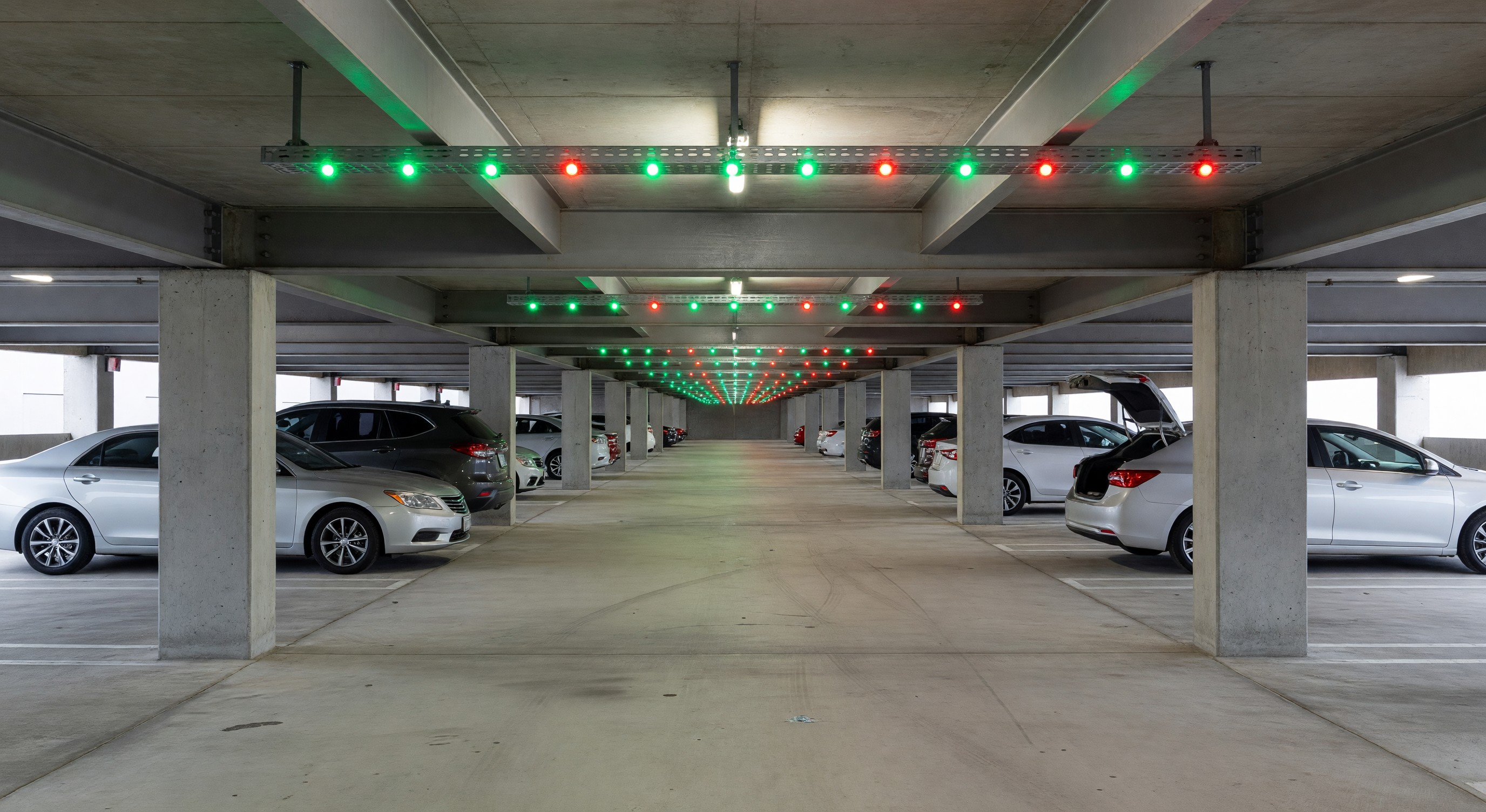
Space-level guidance deploys sensors above or beneath individual parking spaces to detect occupancy in real-time. Overhead LED indicators (green for available, red for occupied) allow parkers to see individual available spaces as they drive the aisle. This eliminates intra-zone search time and provides precise occupancy data. Space-level systems cost significantly more than count-based systems and require more maintenance, but provide superior customer experience and more granular operational data.
Most larger parking structures (over 500 spaces) with dedicated guidance budgets use a hybrid approach: count-based guidance for entry-level zone direction, with space-level sensors and indicators in premium zones (handicapped spaces, reserved stalls, compact areas) or high-demand sections.
Sensor Technologies
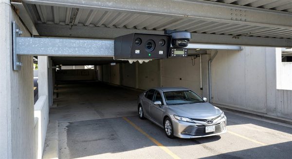
Ultrasonic sensors: Mounted on the ceiling above each parking space, ultrasonic sensors emit sound pulses and detect the reflection from a vehicle below. They are the most widely deployed per-space sensor type in North American facilities. Advantages: no vehicle modification required, moderate cost, established reliability record. Disadvantages: sensitivity to ceiling height, temperature variation, and unusual vehicle profiles (lifted trucks, cargo vans with roof equipment).
Infrared sensors: Similar mounting approach to ultrasonic, infrared sensors detect the heat or proximity of a vehicle. Less commonly deployed than ultrasonic for parking guidance; more common in automated garage applications.
Camera-based occupancy detection: Machine vision systems use cameras to monitor multiple spaces simultaneously, with AI-based image processing detecting occupancy. Camera-based systems can cover more spaces per sensor than ultrasonic, and the same cameras can serve dual purposes (guidance and security/CCTV). Disadvantages: image processing accuracy in challenging lighting conditions (very bright sunlight, deep shadows), and privacy considerations for image retention. Camera-based systems are increasingly competitive as processing costs decline.
Magnetic in-ground sensors: Sensors embedded in the pavement detect the magnetic signature of a vehicle above. Very accurate and weather-resistant, but require pavement cutting for installation (significant disruption for existing facilities) and battery replacement over time.
Loop detectors: Inductive loops embedded in the pavement detect vehicles above. Standard technology for entry/exit counting; less commonly used for individual space detection due to installation complexity at scale.
Display and Wayfinding Integration
The driver-facing component of a PGS is the display system — overhead signs, LED indicators, and/or app interfaces that translate sensor data into actionable information:
Overhead LED count signs: At facility entrances and level/aisle transitions, numerical LED signs display the count of available spaces in each direction or zone. Color coding (green for available, yellow/orange for nearly full, red for full) adds at-a-glance comprehension.
Space-level LED indicators: Individual LEDs (green/red, or multicolor for reserved/accessible status) mounted above each space provide direct visual feedback. Most space-level systems use yellow or blue lighting to indicate reserved or ADA-designated spaces.
Variable message signs: Electronic signs at key decision points (entry to each level, major aisle intersections) display availability counts and directional arrows. Signs are typically daisy-chained via CAN bus or Ethernet from a central PGS controller.
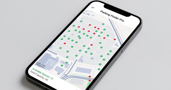
Mobile app integration: Modern PGS platforms expose occupancy data via API, enabling integration with parking apps, navigation apps, and operator-provided customer-facing tools. Real-time availability displayed in a pre-arrival app allows customers to make routing decisions before entering the facility.
Integration with PARCS and Operations
A PGS that operates in isolation provides guidance to customers but limited operational value. Integration with the PARCS and operations reporting platform multiplies the value:
PARCS occupancy synchronization: Some PGS platforms synchronize their occupancy count with the PARCS entry/exit count, using the PARCS data to validate sensor-based counts and reduce count drift over time. This synchronization is typically managed via API.
Reserved space management: PGS can enforce reserved space assignments by displaying a reserved indicator (often blue) and alerting management when a non-authorized vehicle occupies a reserved space.
Reporting and analytics: Space-level occupancy data time-stamped to the minute provides detailed utilization analytics — peak occupancy by zone, average occupancy by hour of day, turnover rates by aisle, and dwell time distributions. This data informs pricing strategy, maintenance scheduling, and future capacity planning.
Vendor Evaluation Criteria
Sensor accuracy: Request documentation of the vendor’s space detection accuracy rate under conditions comparable to the facility (ceiling height, lighting, vehicle mix). Accuracy below 95 percent creates visible errors (red lights over empty spaces, green lights over occupied spaces) that undermine customer trust.
System scalability: Can the system scale to cover the full facility if an initial deployment in select zones proves successful? What is the cost per additional space?
Connectivity and reliability: How does the system handle sensor or network failures? Does the display default to a safe state (showing no information rather than incorrect information) when connectivity is lost?
API and integration documentation: Confirm that real-time occupancy data is accessible via documented API for mobile app and PARCS integration. Proprietary data formats that require vendor-specific integration work create long-term dependency.
Frequently Asked Questions
What is the ROI case for parking guidance systems? ROI for PGS comes from improved utilization (reducing wasted capacity through more efficient space finding), reduced customer frustration and associated customer service cost, and in some facilities, the ability to reduce staffing that was previously needed to direct parkers. ROI periods of 3 to 5 years are typical for space-level systems; count-based systems often have shorter payback periods.
How accurate are camera-based parking guidance systems compared to ultrasonic? In well-configured environments, both achieve 95 to 99 percent accuracy. Camera-based systems can degrade in challenging lighting conditions (direct sunlight, deep shadows at entry/exit transitions). Ultrasonic systems can have accuracy issues with unusual vehicle profiles. Both technologies have mature deployments with documented performance; site-specific conditions should drive technology selection.
Can a parking guidance system integrate with Google Maps or Waze? Yes, through real-time data sharing APIs. Several PGS platforms have established data partnerships that allow real-time availability data to appear in Google Maps, Waze, and similar navigation platforms. Integration requires the PGS vendor to support the data feed format required by the navigation platform.
What maintenance does a parking guidance system require? Ultrasonic sensors require periodic sensitivity calibration and lens cleaning. Overhead LED indicators require bulb/module replacement over time. Count-based systems require sensor cleaning and accuracy validation against manual counts. Budget for annual preventive maintenance of 3 to 5 percent of initial system cost for a well-maintained PGS.
Takeaway
Parking guidance systems range from simple entry/exit count displays to sophisticated space-level sensor networks with real-time app integration. The appropriate investment level depends on facility size, peak occupancy patterns, and the operational value of detailed utilization data. For facilities that regularly exceed 85 percent occupancy, the customer experience and utilization improvement from guidance systems provides measurable return. The technology selection should be driven by site-specific conditions (ceiling height, lighting, vehicle mix), integration requirements, and long-term maintenance economics rather than technology novelty.
Further Reading from Authoritative Sources
- Transportation Research Record parking guidance system effectiveness research — The Transportation Research Board publishes Transportation Research Record, which is explicitly cited in the article as the source for parking guidance effectiveness data.
- IPMI parking guidance system technology standards and vendor evaluation resources — IPMI publishes parking guidance system technology guidance, vendor evaluation frameworks, and operational case studies for parking professionals.