Wayfinding is the system by which drivers navigate from public streets to parking stalls and then from parking to their destination. In complex parking facilities — multi-level structures, sprawling campus lots, urban districts with dispersed parking assets — poor wayfinding translates directly into driver frustration, circling traffic, and reduced facility utilization. A well-designed wayfinding system reduces search time, distributes demand across the facility, and improves user satisfaction regardless of facility complexity.
The Case for Systematic Wayfinding
Research published by Victoria Transport Policy Institute and transportation consultancies consistently shows that 30 to 40 percent of urban driving in dense commercial areas involves drivers searching for parking. This “parking cruising” generates congestion, emissions, and driver frustration disproportionate to the actual shortage of available spaces. Effective wayfinding doesn’t create parking where none exists, but it helps available spaces be found quickly, reducing search time and circling.
For facility operators, wayfinding drives revenue. Underutilized levels or sections of a garage — often simply because they are hard to find — represent lost revenue. Guidance systems that direct drivers to available capacity convert latent utilization into realized revenue.
Static Wayfinding: The Foundation
Static wayfinding includes signs, pavement markings, and architectural cues that remain constant regardless of occupancy or time of day. Any effective wayfinding program begins with a robust static layer, because static systems function in all conditions, require no technology, and provide the navigational skeleton on which dynamic systems build.
Static wayfinding components:
Level identification: Clear, consistent numbering or naming of every level (Level 1, Level 2, etc. or thematic names for memorable facilities). Level IDs should appear at every stairwell, elevator, and ramp entry on that level, in large format visible from both pedestrian and driver eye levels.
Zone identification: Color or alphanumeric coding of zones within levels (Red Zone, Level 1A, etc.) allows users to identify their parking location for return navigation. Zones should be of manageable size — no more than 100 to 150 stalls per zone — to enable reliable recall.
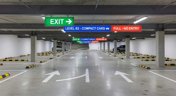
Directional arrows: Mounted at every decision point — aisle intersections, ramp entries, elevator lobbies — directional arrows for exits, stairwells, and general flow should be clear, consistent, and redundant (placed at decision point and 30 to 50 feet before it).
Pedestrian egress maps: Posted at elevator lobbies and major pedestrian exits, overview maps with “You Are Here” indicators help parkers understand the relationship between their parking location and their destination.
Dynamic Wayfinding: Real-Time Guidance
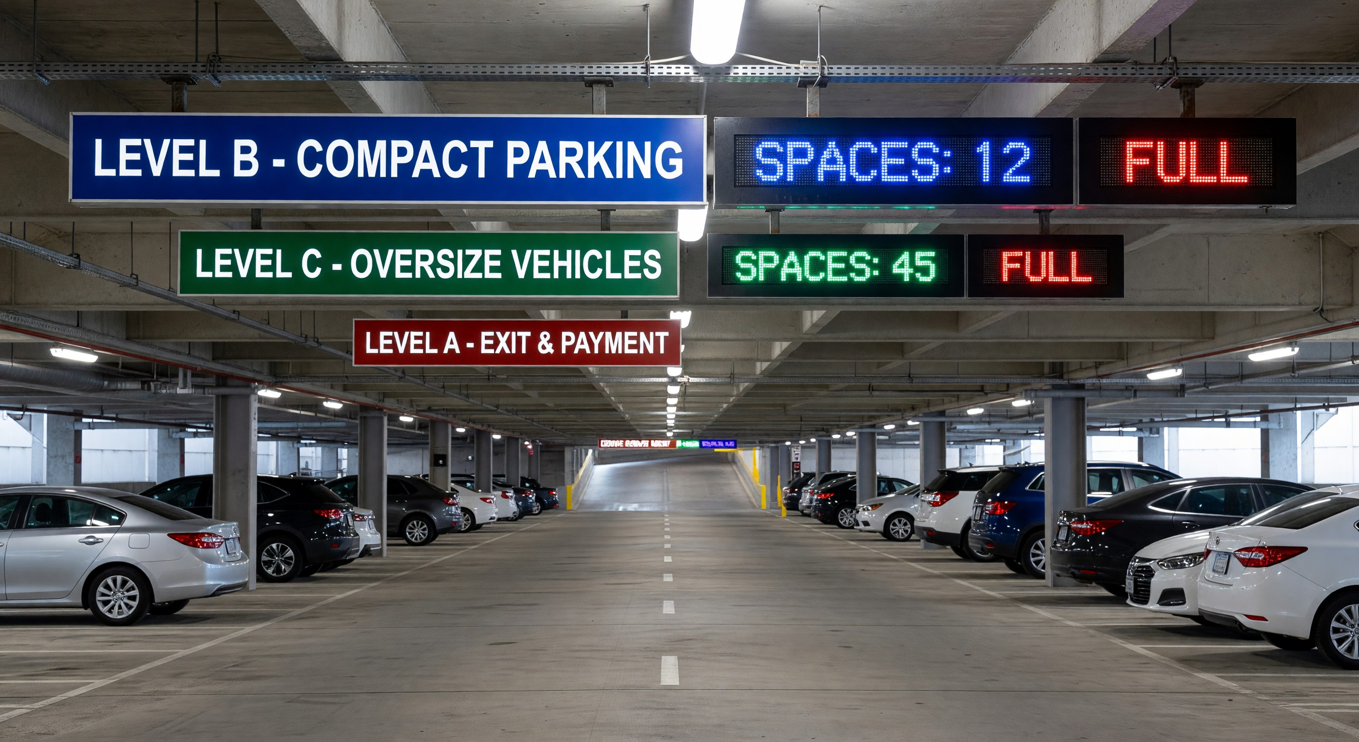
Dynamic wayfinding overlays real-time occupancy information on the static navigational framework. Variable message signs (VMS) at facility entries and aisle terminals display available space counts, guiding drivers to areas with vacancy rather than circling through full sections.
Entry-level guidance: At the facility entry lane, a VMS displays total available spaces — or, in zoned facilities, availability by level or zone. This allows drivers to make level selection before entering the facility.
Aisle-level guidance: At the entry to each drive aisle, a VMS or LED indicator (green = spaces available; red = full) provides the final navigational decision before the driver commits to an aisle search.
Space-level guidance: Individual stall sensors with overhead LED indicators (green/red) guide drivers to the first open stall. This is the highest-resolution guidance and is typically limited to structured garages where the infrastructure investment is justified by high turnover and utilization.
Dynamic systems depend on accurate occupancy data. Ultrasonic sensors, camera-based detection, and loop detectors all provide different accuracy and cost profiles (see the parking guidance system technology article for detailed comparison). Stale or inaccurate occupancy counts are worse than no counts — a “2 Available” display that leads a driver to a full section destroys user trust in the system.
Color Coding Strategies
Color coding supports navigation by creating memorable spatial cues. Effective color coding in parking structures applies consistent colors to levels, zones, or both:
Level-based color coding: Each level has a single dominant color (red = Level 1, blue = Level 2, green = Level 3, yellow = Level 4). Colors appear on columns, wall surfaces, and signage throughout the level. Return navigation is intuitive — “I’m on the red level.”
Zone-based color coding: Each zone or section within a level has a distinct color, with level numbers used for level identification. This allows finer-grained navigation in large facilities.
Color selection for parking facilities should account for lighting conditions: some colors (yellow-green, orange) remain distinguishable under high-pressure sodium or warm LED lighting; dark colors (navy, forest green) can be hard to read on painted columns under inadequate lighting.
Color coding must be reinforced at exit points — stairwells and elevators should display the color of each level accessible from that point. Printed reminder cards (“You are parked on Level 3 — Green”) can be provided to monthly parkers or by staff.
Technology Integration
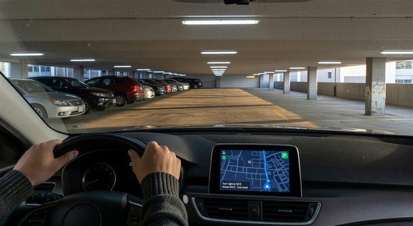
Modern wayfinding increasingly integrates with mobile navigation. Facilities that provide real-time occupancy data through APIs can have their available spaces displayed in navigation apps (Google Maps, Waze, Apple Maps) and parking search platforms. This brings external wayfinding — guiding drivers to the facility from off-site — into the same data ecosystem as internal guidance.
Digital parking portals and QR codes posted at stairwells allow parkers to access facility maps on their phones, reducing signage requirements and enabling dynamic updates (event messages, closed areas) without physical sign changes.
Frequently Asked Questions
What is the difference between static and dynamic parking wayfinding? Static wayfinding includes signs, color coding, and level identification that remain constant. Dynamic wayfinding adds real-time occupancy information through variable message signs, LED indicators, or mobile apps. Effective systems use both layers.
How should parking levels be identified for wayfinding? Clear, consistent numbering (Level 1, Level 2) with color coding is the most effective combination. Level IDs should appear at every stairwell, elevator, and ramp entry. Colors should be applied broadly enough on wall and column surfaces to be immediately recognizable.
What size zone is manageable for color-coded wayfinding? Most wayfinding consultants recommend zones of no more than 100 to 150 stalls each. Larger zones are difficult for parkers to recall their specific location within the zone, reducing the effectiveness of zone-based navigation.
Can parking wayfinding data be shared with navigation apps? Yes. Facilities with API-enabled parking guidance systems can share real-time occupancy data with mapping platforms and parking search apps. This extends wayfinding guidance to drivers before they enter the facility, reducing approach congestion.
Takeaway
Effective parking wayfinding combines a robust static foundation — level IDs, zone color coding, directional signs — with dynamic occupancy guidance that routes drivers to available spaces in real time. The system must be designed as a hierarchy, addressing every decision point from street approach to individual stall. Investment in wayfinding pays dividends in reduced search time, better utilization of full facility capacity, and higher user satisfaction — all of which directly support parking revenue and operator reputation.
Further Reading from Authoritative Sources
- IPMI parking wayfinding standards and parking guidance technology resources — IPMI is the primary professional association for parking industry practitioners and publishes wayfinding standards, technology guidance, and best practices referenced throughout this article’s domain.
- ITE transportation engineering standards for parking facility signage — The Institute of Transportation Engineers publishes technical standards for parking facility signage, directional signing, and traffic control that underpin the static wayfinding layer described in this article.